The Yenisei River. Economic Utilization and General Characteristics
The broad and powerful river Yenisei. How many poems are devoted to her, how many paintings and even monuments! The unprecedented power of the Yenisei, its beauty always inspired writers, poets and artists.
General characteristics of the river
The Yenisei received its name from the Evenk "Ionesi", which means "big water". The name of the river in other peoples sounds: Enzyayam, Hook, Hem, Kim.

This river is the natural boundary betweenEastern and Western Siberia. To the left of the river are the plains of Western Siberia, and on the right side the mountain taiga begins. Yenisei flows through all climatic zones of Siberia: in the upper reaches of the river there are camels, and in the lower reaches live polar bears.
This powerful river originates in the city of Kyzyl,where they merge into one two rivers - the Big and the Lesser Yenisei. The first 188 km of the river is called the Upper Yenisei. Within the Tuvinian basin, the river is riddled with ruts, broken into many branches, and the width reaches 650 m. The depth at the ruts is equal to 1 m, on the reaches - 12 m.
At the mouth of the Lower Tunguska, the width of the Yenisey River valley reaches 40 km.
Sopochnaya Karga is the estuary of the river. The Yenisei Delta begins near the village of Ust-Port. There are several main branches: Small Yenisei, Big Yenisei, Stone Yenisei and Okhotsk Yenisei.
At the Kara Sea, the Yenisei forms a gulf.
Water regime of the Yenisei River
This river has a mixed type of food, but snow predominates, its share is about 50%, the share of rain-38%, underground (in the upper reaches of the river) - 16%. Ledostav begins to form in October.

Flood begins in April - May. During the spring ice drift, congestion may form. The water level at this time can range from 5 m in the extended upper reaches of the river, up to 16 m in narrowed sections.
The Yenisei River ranks first among the rivers of Russia in terms of runoff. It is 624 km³.
The average water discharge is 19800 m3 / s (at the mouth), the maximum is at the river Igarka - 154,000 m3 / s.
The tributaries of the Yenisei
Left: Abakan, Kas, Khemchik, Sym, Kantegir, Dubce, Turukhan, Tanama, Big and Small Heta, Elogui
Rights: Us, Tuba, Sisim, Kebezh, Mana, Angara, Kan, Bolshoy Pete, Bakhta, Podkamennaya and Lower Tunguska, Dudinka, Khantayka, Kureika.
These are the largest tributaries, they are used in the economy, like the Yenisei River. The economic use of these waters is very important for humans.
Settlements
Cities: Kyzyl, Sayanogorsk, Krasnoyarsk, Abakan, Shagonar, Minusinsk, Sosnovoborsk, Lesosibirsk, Zheleznogorsk, Yeniseisk, Dudinka, Igarka.
Small settlements: Karaul, Ust-Port, Cheryomushki, Shushenskoe, Main, Berezovka, Kazachinsky, Ust-Abakan, Kureika, Turukhan.
Yenisei River - economic use of water
Economic use of the Yenisei plays an important role for the country. This river is an important waterway of the whole Krasnoyarsk Territory. Throughout 3013 km (from Sayanogorsk to the mouth) the river is navigable continuously.

Main ports: Krasnoyarsk, Abakan, Maklakovo, Strelka, Turukhansk, Ust-Port, Igarka, Yeniseisk, Kyzyl and others.
The Ob-Yenisei Canal, which connected the twolarge rivers of Russia, was built at the end of the XIX century. It was very important, like the Yenisei River. Economic use of the channel: it was an alloy of wood, transportation of minerals. Currently, the channel is abandoned and not used.
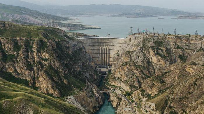
The use of the Yenisei River by man has a considerable influence on the ecological situation, considering that several reservoirs and hydroelectric power stations have been built on the river.
HPP: Krasnoyarskaya, Sayano-Shushenskaya and Mainskaya.
The Yenisei River. Economic use and its protection

Uncontrolled fishing leads to a decrease in species diversity.
The Yenisei River played a huge role.
The economic use of its waters at nuclear power plants ledto radiation contamination of water in the river. So in the 1950s several nuclear reactors were put into operation at the mining chemical plant, which used water from this river. After cleaning the nuclear reactors, the water was discharged back into the river.
The use of the Yenisey River by man leads toThe fact that his water is littered with various garbage (both domestic and petroleum products). Therefore, it is necessary to take measures to protect the environment in order to preserve the flora and fauna of the river and the purity of its waters.
</ p>