Sulak River - recreational and energetic pearl of Dagestan
Dagestan is an incredibly beautiful mountainous republic,It is sandwiched between the Great Caucasus and the shore of the Caspian Sea. In this article we will talk about the nature, geography and rivers of the republic. In particular, about the Sulak River - a real water pearl of the south of Russia.
General features of the nature of Dagestan
The Republic is located in the extreme south-westRussia. Geographically, it is interesting in that it borders on five states (with regard to maritime borders as well): Georgia, Azerbaijan, Iran, Kazakhstan and Turkmenistan. The northern part of Dagestan is represented by lowlands (or the so-called Nogai steppes), the southern part by foothills and mountains of the Greater Caucasus. The climate of the territory is moderately continental and rather arid.
The nature of Dagestan, despite minorthe size of the region, incredibly beautiful and diverse. Steppes and mountain peaks, steep rocks and waterfalls, canyons and the purest rivers - all this can be seen within one republic!

Dagestan is located in severalnatural floristic zones. Semi-desert species grow in the north of the republic. With the advance to the south they are replaced by succulent meadows and forests. Alpine type plant formations occur in the highlands. In general, in this region there are about 4.5 thousand plant species, a quarter of which are endemics.
Lakes and rivers of Dagestan
More than 6200 rivers are in the republic. All of them belong to the Caspian basin. However, only 20 of them transmit their waters to the huge sea-lake. The rest are spent on irrigation of agricultural land or are lost in the Caspian lowland.
About 90% of all rivers of Dagestan are classified as mountainous. Their valleys are narrow and deep, the flow velocity in them is very high. Due to this, they do not freeze even in the harshest winters. The largest river of Dagestan is Terek. Its total length is 625 kilometers. The second largest in the republic is the Sulak River.
Within Dagestan there are several hundredlarge and small lakes. The largest (and most famous) of them is Lake Kezenoy-Am. It is the deepest pond in the North Caucasus (maximum depth is 72 meters). The lake has an important recreational and tourist value.
Sulak River: general information
"Sheep water" - this is how the name of this watercourse is translated from the language of the Kumyks. The total length of the Sulak River is 169 kilometers, and the catchment area is about 15,000 square kilometers. km.
The source of Sulak is considered to be the confluence of twoother rivers: the Andi and Avar Koisu. Both of them originate on the slopes of the Caucasian ridge. In the upper reaches the Sulak River carries its waters along a deep and incredibly beautiful canyon. Then it crosses the Ahetlin Gorge, after which its valley expands significantly. In the lower reaches the river forms a fairly large delta and flows into the Caspian Sea.
It feeds on Sulak mostly with thawed snowwaters. Flood in the river is observed from May to September, and low water (minimum water level) - from December to March. The turbidity of the water in the lower reaches of Sulak is 100 times higher than in its upper reaches.

On its way, the Sulak River receives the waters of a large number of small tributaries. The largest of them are Ah-Su, Tlar, Chvakhun-bak and Maly Sulak.
Economic use and recreational potential of the river
Sulak is often referred to as the energypearl of the North Caucasus. It is on this river that the largest hydroelectric power station of Dagestan - Chirkeyskaya - is located. Her employees can only be envied. After all, the power plant is in an incredibly picturesque place! In addition to the Chirkeyskaya, on the Sulak River there are five more hydroelectric power stations of lesser capacity.
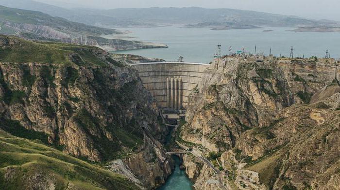
The pure waters of Sulak are used for water supplythe city of Kaspiisk and Makhachkala. In the 70s of the last century, the Chirkey reservoir (the largest in Dagestan) was built on the river. Due to the numerous outcrops of crystalline rocks, its surface has a beautiful azure hue.
Of course, Sulak is used inRecreational and tourist purposes (fishing, water and walking tours). The Sulak canyon is of great interest to many tourists, the maximum depth of which reaches 2 km! It is quiet and almost deserted, only lonely eagles beautifully circled high in the sky above the abyss of a rocky canyon.
</ p>